Why Old Streets Bend Around the Ground
Why old streets bend around the ground: read how slopes, streams and old boundaries shape a route, and learn which clues call for closer checking.
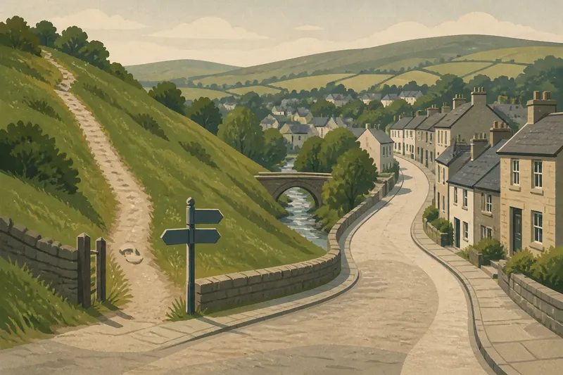
At the bottom of a hill, one street may climb straight towards the ridge while another curves along its side. Why old streets bend around the ground becomes clearer when you look at the land the route crosses, not just the line on a map. A bend can reflect a slope, a watercourse, an old boundary or several changes made at different times.
Begin with the route’s shape and setting. Then compare those features with maps and records that can help explain them. A street’s present course is visible; the decisions that produced it may not be.
What does the street’s shape tell you?
Start at a junction with a clear view along the road. Walk each branch far enough to see whether it rises, falls or stays at much the same level. Notice where the route narrows, changes direction or passes between older-looking property lines.
These details suggest questions, not answers. A gradual curve may fit a hillside, but it might also follow a boundary or connect places that were once separate. Look at the whole route and its surroundings before settling on an explanation.
- If the road climbs steadily, check whether it is crossing a slope directly; if it is, compare nearby routes for a gentler line, but if not, look for a change in ground level or a junction that explains the rise.
- If several lanes run at similar heights, compare their direction with the hillside; if they track it, slope may have shaped their course, but if they do not, examine property lines and connecting routes instead.
- If a street bends beside a wall or row of buildings, see whether the line continues along a boundary; if it does, check older maps for a matching division, but if it does not, treat the bend as unexplained by that boundary.
- If doorways sit above or below the pavement, note the change in level; if it continues along the street, the ground or street level may have shifted, but if it occurs only at one building, do not use it to explain the whole route.
- If a lane ends at a sharp turn or narrow gap, check whether another path continues beyond it; if one does, follow the connection on a map, but if none appears, record the lane as a route whose purpose remains unclear.
- If the road dips near a bridge or low-lying green, look for a watercourse or drainage feature; if one aligns with the dip, compare it with a map, but if not, consider other causes of the low point.
How might slope shape a route?
A road across a hillside can follow a contour, keeping to a similar height, instead of taking the shortest line uphill. That gentler course may explain why it curves while a footpath nearby climbs more directly. The contrast is useful, but it does not tell you whether the road began as a track, a boundary or a planned street.
Imagine you are looking at an invented hillside settlement. A lane curves around a steep green, while a path across the green climbs sharply. You note that the lane rises gradually and the path rises abruptly, then compare both lines with a contour map. If the lane tracks the hill’s side, the map supports the idea that its course accommodates the slope; it still cannot establish when or why the lane was first made.
What can a watercourse explain?
Water tends to collect in lower ground, so a stream, valley or drainage channel can influence where streets cross and where they turn. A bridge may mark a crossing point. A line of low ground continuing through a park or between buildings may suggest a channel that is now covered or altered.
Look for more than one clue before connecting a bend to water. A dip in the road, a bridge and a mapped stream that follow the same line form a stronger case than any one feature alone. Yet the street might have changed after the watercourse was channelled, or the low ground might have another cause.
After rain, from a safe public place, you can see how runoff moves along today’s pavement. Treat this as evidence about present drainage only. Do not enter culverts or approach fast-flowing water.
Which maps and records help explain the route?
Use a current street map to follow the route, then compare it with a contour map and historical maps where available. Look for changes in street alignment, watercourses, field edges and property boundaries. Maps were made for particular purposes, so a missing lane or stream may reflect the map’s scope rather than its absence on the ground.
Local libraries and town or county archives may hold estate maps, road descriptions, drainage plans and records of boundary changes. Check who made each record, what area it covers and what it was intended to show. A drainage plan can identify a culvert without explaining why the street above it bends.
Keep your account tied to the source. A map can show that a route followed a certain line at the time it was drawn. A document describing road construction or a boundary can support a more specific explanation. If sources disagree, give each claim its origin rather than blending them into one story.
What questions help distinguish a clue from an explanation?
Can a curved street prove that a stream once ran there?
No. A curve may fit a former watercourse, but a boundary or slope could produce a similar line. Look for a mapped channel, drainage record or matching landform before making that connection.
Does a narrow lane mean it is old?
Not by itself. Compare maps from different periods and look for records that name the lane or describe its use. Appearance can guide your search, but it cannot date a route.
What if local accounts and maps differ?
Keep both accounts and note who provided them and when. They may refer to different stretches of road or different changes; seek another record before choosing between them.
How should you describe an uncertain street history?
Use wording that matches what the evidence can support. “The lane follows the lower side of the slope” describes an observable relationship. “The lane was built to avoid the stream” claims intention and timing, so it needs evidence that connects the route to those decisions.
For a clear account, name the visible feature, the source that supports your interpretation and the point that remains unresolved. That approach makes why old streets bend around the ground easier to explain without turning a plausible clue into a settled history. A map or archive catalogue can then guide the next question: what evidence would distinguish a route shaped by land from one shaped by later property lines?